
On a frigid morning in the Cascade Mountains of Washington State, Toby Rodgers, a hydrologist with the United States Department of Agriculture’s (USDA) Natural Resources Conservation Service (NRCS), moved methodically across a blanket of white. Strapped into snowshoes to navigate the deep drifts, Rodgers carried a tool that appeared deceptively simple: a long, hollow aluminum tube equipped with a sharp, serrated bit at its base. This device, known as the Church Sampler, remains the cornerstone of water management in the Western United States, despite being over a century old. By driving the tube through the snow to the ground and weighing the resulting core, Rodgers can determine the Snow Water Equivalent (SWE)—a metric that dictates how much water will eventually flow into the rivers, reservoirs, and irrigation canals that sustain millions of people downstream.
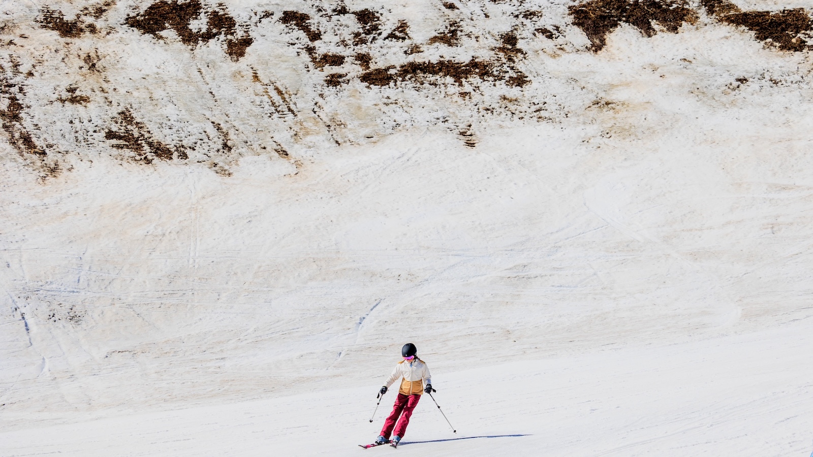
As the climate changes, the data collected by Rodgers and his colleagues has taken on a new level of urgency. The Western U.S. is currently grappling with a phenomenon known as a "snow drought," where rising temperatures cause precipitation to fall as rain rather than snow, or cause existing snowpacks to melt prematurely. This shift threatens the delicate balance of water storage that the region has relied upon since the early 20th century. The humble Church Sampler, once a tool of academic curiosity, is now a primary instrument in the fight to predict and mitigate the impacts of a warming world.

The Genesis of Snow Science: James Church and the Mount Rose Sampler
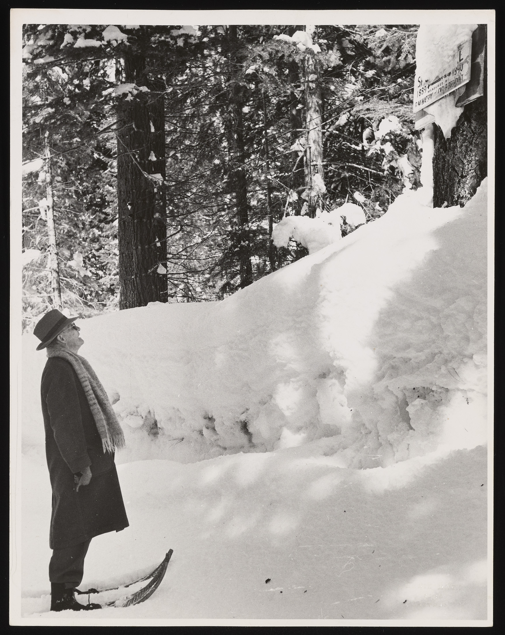
The history of snow science is inextricably linked to the work of Dr. James Edward Church, a professor of the classics and art history at the University of Nevada, Reno. While his professional life was dedicated to Latin and ancient literature, his passion lay in the rugged peaks of the Sierra Nevada. In the early 1900s, Church became fascinated by the relationship between mountain snow and the water levels of Lake Tahoe and the Truckee River. At the time, water rights were a source of frequent and often violent contention between farmers in Nevada’s Lahontan Valley and residents along the lake’s shores.
Church hypothesized that if one could accurately measure the amount of water held in the mountain snowpack before it melted, downstream communities could better manage their reservoirs and prepare for either floods or droughts. In 1906, he established the Mount Rose Weather Observatory at an elevation of 10,800 feet. It was here that he developed the "Mount Rose Sampler," the precursor to the modern Church Sampler.
The innovation of Church’s device was its ability to measure density rather than just depth. Because snow can be light and fluffy or heavy and wet, depth alone is a poor indicator of water content. By weighing a core sample of snow, Church’s tool allowed for the direct calculation of water weight. This breakthrough transformed water management from a game of guesswork into a rigorous scientific discipline. By the 1930s, the federal government recognized the utility of Church’s methods, leading to the creation of the Federal-State Cooperative Snow Survey Program, which continues to operate under the USDA NRCS today.
Technical Mechanics of the Church Sampler
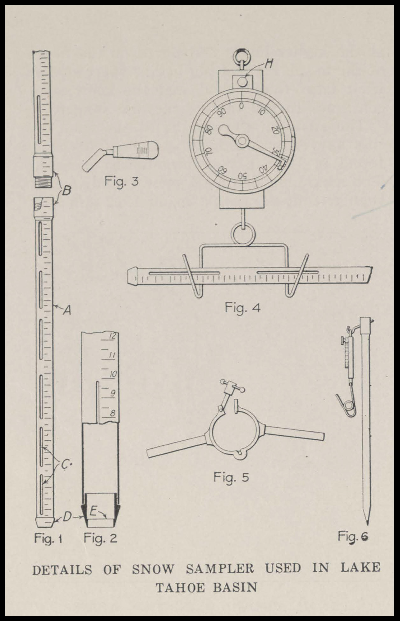
The Church Sampler consists of several sections of duralumin or aluminum tubing, each roughly 30 inches long, which can be threaded together to measure snowpacks of varying depths. The bottom section is fitted with a steel cutter bit with teeth designed to penetrate through icy crusts and even thin layers of soil to ensure a complete core is retrieved.
Once the tube is driven vertically through the snowpack to the ground, the surveyor pulls it out, ensuring the snow core remains inside. A small spatula or "high-tech butter knife" is used to remove any soil from the bottom of the tube. The tube and its contents are then suspended from a portable spring scale. The scale is calibrated so that the weight of the snow is read directly as inches of water. This simple physical measurement provides a ground-truth reality that even the most advanced satellite sensors struggle to replicate with 100 percent accuracy.
The 2026 Snow Drought: A Regional Crisis
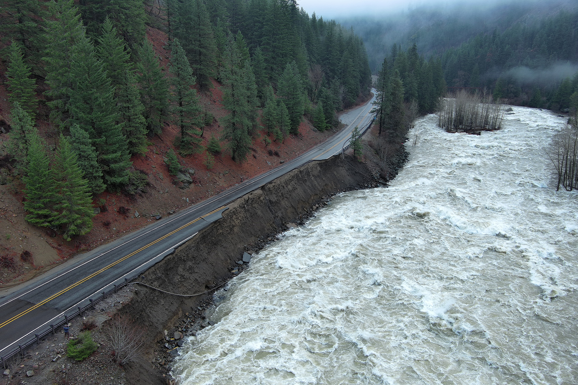
The importance of manual sampling has been underscored by the volatile weather patterns observed in the mid-2020s. In the winter of 2025–2026, many parts of the West experienced what meteorologists call a "warm winter." While total precipitation levels in some areas remained near historical averages, the form of that precipitation shifted. At Stevens Pass in Washington, where Rodgers conducts his surveys, a series of powerful atmospheric rivers brought torrential rain instead of the expected heavy snow.
This "rain-on-snow" event had catastrophic consequences. Without a deep snowpack to absorb and slowly release the moisture, the rainwater rushed immediately into stream channels. In December 2025, a massive flood event triggered by these rains washed out sections of Highway 2 near Stevens Pass, closing a vital transportation artery for months.
By April 1, 2026—the date traditionally used by hydrologists to mark the peak of the winter snowpack—the data painted a grim picture. Across much of the Western U.S., snow levels were significantly below normal. In parts of California and the Southwest, the snowpack was recorded at just 17 percent of its historical average. This deficit creates a "snow drought," where the natural "water tower" of the mountains fails to materialize, leaving reservoirs dangerously low heading into the peak demand months of July and August.
Supporting Data and Long-term Climate Trends
The current crisis is not an isolated incident but part of a documented long-term decline in Western snowpacks. A comprehensive review published in the journal Nature in 2021 analyzed decades of satellite and ground-based data. The study concluded that the Western U.S. could lose approximately 25 percent of its historical mountain snowpack over the next 25 years if current warming trends continue.
Furthermore, the "zero-snow" line—the elevation at which snow remains on the ground throughout the winter—is steadily creeping higher. Monitoring sites that have provided consistent data for over a century are now frequently recording "snow-free" days in mid-winter. As Toby Rodgers noted during his field observations, sites that were once reliably buried in several feet of snow are now often bare or covered in thin, icy patches that offer little water value.
The implications for the regional economy are profound. The American West relies on snowpack for roughly 75 percent of its water supply. This water is critical for:
- Agriculture: The Central Valley of California and the Yakima Valley in Washington depend on predictable runoff for irrigation.
- Hydroelectric Power: Low river flows reduce the capacity of dams to generate clean electricity, often forcing a reliance on fossil fuel backups.
- Municipal Supply: Major metropolitan areas, including Los Angeles, Phoenix, and Las Vegas, draw significant portions of their water from snowmelt-fed systems like the Colorado River.
- Ecosystem Health: Cold water runoff is essential for the survival of salmon and trout species, which cannot thrive in the warmer waters caused by low flows.
Official Responses and the Future of Water Management
In response to these shifting conditions, state and federal agencies are attempting to modernize their approach to water accounting. The USDA has expanded its SNOTEL (Snow Telemetry) network, which consists of over 900 automated stations that provide real-time data on snow depth, weight, and air temperature. Additionally, NASA and various state agencies are utilizing "Airborne Snow Observatories"—planes equipped with LIDAR and spectrometers that can map snow depth across entire watersheds with centimeter-scale precision.
However, officials emphasize that these high-tech solutions do not replace the need for manual surveys. The Church Sampler provides a vital "ground truth" that allows scientists to calibrate their remote sensing equipment. "We measure snow still to this day with that tube because it is the gold standard for accuracy," Rodgers explained.
Water managers are also adjusting their reservoir operations. Historically, dams were managed to prioritize flood control in the spring and water storage in the summer. With the shift toward more rain and earlier melts, managers are being forced to adopt "Forecast-Informed Reservoir Operations" (FIRO). This strategy uses advanced meteorological modeling to decide when to hold water and when to release it, attempting to capture the "flashy" runoff from rain events that would have previously been stored as snow.
Broader Impact and Conclusion
The work of James Church a century ago was born out of a need to resolve local disputes over a lake. Today, that same work is the foundation for managing a continental-scale water crisis. The transition from a snow-dominated hydrologic system to a rain-dominated one represents one of the most significant challenges to the stability of the American West.
As scientists like Toby Rodgers continue to trudge through the mountains of the Cascades and the Sierras, the data they collect serves as an early warning system for the droughts and wildfires that are becoming increasingly common. The Church Sampler remains a testament to the power of simple, elegant engineering in the face of complex environmental change. While technology will continue to evolve, the fundamental act of weighing the winter’s snow remains the most reliable way to glimpse the future of the West’s most precious resource. The "snow drought" of the 2020s is a stark reminder that while the tools of the past remain effective, the climate they were designed to measure is rapidly entering uncharted territory.

