
The global understanding of coastal risk is undergoing a radical and alarming transformation as new scientific evidence reveals that sea levels are significantly higher than previously estimated and that land in many of the world’s most populous regions is sinking at an accelerated rate. For decades, international climate policy has relied on global models to predict flood risks, yet two major new studies suggest these models have systematically underestimated the danger. The convergence of rising baseline sea levels and rapid land subsidence means that tens of millions of people, particularly in the Global South, are facing the threat of permanent inundation decades earlier than anticipated.
Researchers now argue that the "story of coastal vulnerability" is being rewritten. While climate change continues to drive the thermal expansion of oceans and the melting of polar ice, local factors—ranging from inaccurate mathematical modeling of the Earth’s shape to the aggressive extraction of groundwater—are creating a "double whammy" for coastal megacities. The implications are profound, suggesting that current infrastructure projects and relocation strategies may already be insufficient to meet the looming crisis.
The Flaw in the Foundation: Why Sea Level Estimates Were Wrong
A groundbreaking study led by Katharina Seeger and Philip Minderhoud of Wageningen University & Research has identified a significant "methodological blind spot" in how scientists calculate current sea levels. For years, the majority of peer-reviewed literature and reports from the Intergovernmental Panel on Climate Change (IPCC) have relied on the "geoid"—a mathematical model representing the Earth’s shape based on rotation and gravity. While the geoid provides a useful approximation for global calculations, it assumes a static, calm ocean.
The Dutch researchers found that by ignoring ocean dynamics—such as prevailing winds, ocean currents, and localized thermal expansion—these models have produced a baseline that is too low. After analyzing real-world data from 385 tidal gauges across the globe, Seeger and Minderhoud concluded that actual sea levels are, on average, nearly one foot (9.4 to 10.6 inches) higher than the geoid-based estimates used in most scientific papers.
This discrepancy is not uniform. In parts of Southeast Asia, actual sea levels were found to be three feet or more higher than predicted by standard models. This error is particularly prevalent in the Global South, where ocean dynamics are more intense and where fewer localized studies have been conducted to correct the global models. Because many of these regions have relied on "cut-and-paste" modeling from Western-centric data, they have inadvertently planned for a reality that does not exist. The study concludes that approximately 80 million people are currently living on land that sits below the actual sea level—nearly double the previous estimates.
The Sinking Land: Satellite Data Reveals a Sinking Reality
Compounding the issue of rising water is the physical lowering of the land itself, a process known as subsidence. While sea-level rise is a global phenomenon driven by atmospheric warming, subsidence is often a local, human-induced crisis. A second major study, conducted by Leonard Ohenhen of the University of California, Irvine, utilized satellite-mounted radar (InSAR) to create high-resolution 3D maps of 40 of the world’s largest river deltas.
The findings are stark: more than half of the deltas studied are actively sinking. In 18 of these cases, the rate of land subsidence actually exceeds the rate of sea-level rise. In the most extreme instances, the land is disappearing ten times faster than the ocean is rising. This means that for residents of these deltas, the "effective" sea-level rise is doubled or tripled, leading to rapid saltwater intrusion, the destruction of farmland, and the collapse of urban infrastructure.
The primary driver of this subsidence is the over-extraction of groundwater. As growing coastal populations pump water from underground aquifers to meet the demands of industry, agriculture, and daily life, the soil above compresses and collapses. Additionally, the construction of upstream dams and levees has starved deltas of the natural sediment deposits required to maintain their elevation against the erosive power of the sea.
A Chronology of Coastal Science and Shifting Projections
The evolution of how we measure the sea highlights the growing gap between theoretical modeling and physical reality:
- Late 19th Century – 1990s: Sea level monitoring relied almost exclusively on coastal tide gauges. While accurate for specific points, these gauges were geographically sparse, particularly in Africa and South America.
- 1992: The launch of the TOPEX/Poseidon satellite revolutionized the field by providing the first global maps of sea-surface height, though it still struggled to capture the nuances of "coastal" sea levels where land and water meet.
- 2000s – 2010s: Scientists increasingly adopted "geoid" modeling to fill in data gaps in regions without tide gauges. This period saw a proliferation of studies that used these mathematical approximations as a baseline for future projections.
- 2019: Indonesia announced the relocation of its capital from Jakarta to Borneo, citing the fact that parts of the city were sinking by up to 10 inches per year. This served as a global wake-up call regarding the speed of subsidence.
- 2024 – 2025: The publication of the Seeger-Minderhoud and Ohenhen studies provides the first comprehensive, high-resolution evidence that both our sea-level baselines and our land-level projections were fundamentally flawed.
Global Hotspots: Where the Crisis is Most Acute
The intersection of these two studies points to several "red zones" where the risk of inundation is imminent.
The Mekong Delta, Vietnam
Home to over 17 million people and a vital global rice basket, the Mekong Delta is sinking due to groundwater pumping and a lack of sediment caused by upstream dams in China and Laos. Previous forecasts suggested the delta would remain safe until sea levels rose by five feet. However, Minderhoud’s research shows that the current water level is already much higher than the land in many areas, meaning the delta is on the verge of large-scale submergence today.
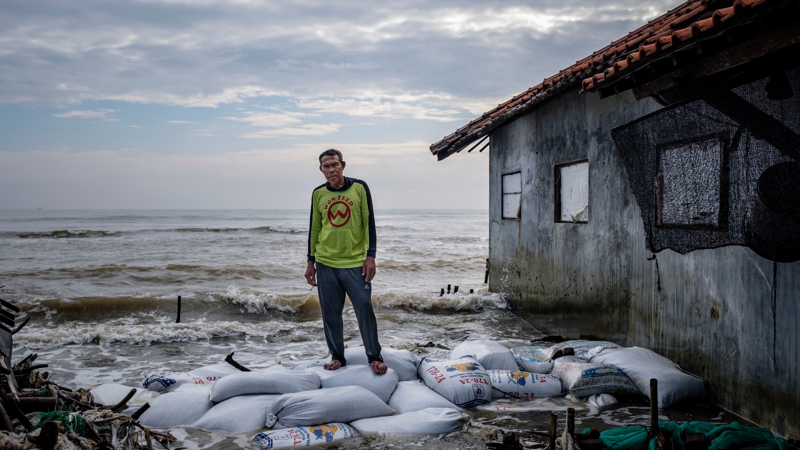
Java, Indonesia
Jakarta has become the global poster child for subsidence, with some districts sinking 13 feet since 1970. However, the crisis is spreading. In Semarang, a city of 2 million, the rate of sinking is 20 to 50 times higher than the rate of sea-level rise. In late 2024 and early 2025, catastrophic floods swept through neighborhoods that were once considered safe, forcing residents to perpetually raise their homes on stilts.
The Nile Delta, Egypt
The Nile Delta, which contains two-thirds of Egypt’s agricultural land, is being hit by a "triple threat." The Aswan High Dam has cut off the sediment supply, groundwater pumping is collapsing the land, and the Mediterranean is rising. The new data suggests the coastline is retreating by over 300 feet per year in some locations, poisoning the soil with salt and threatening the ancient city of Alexandria.
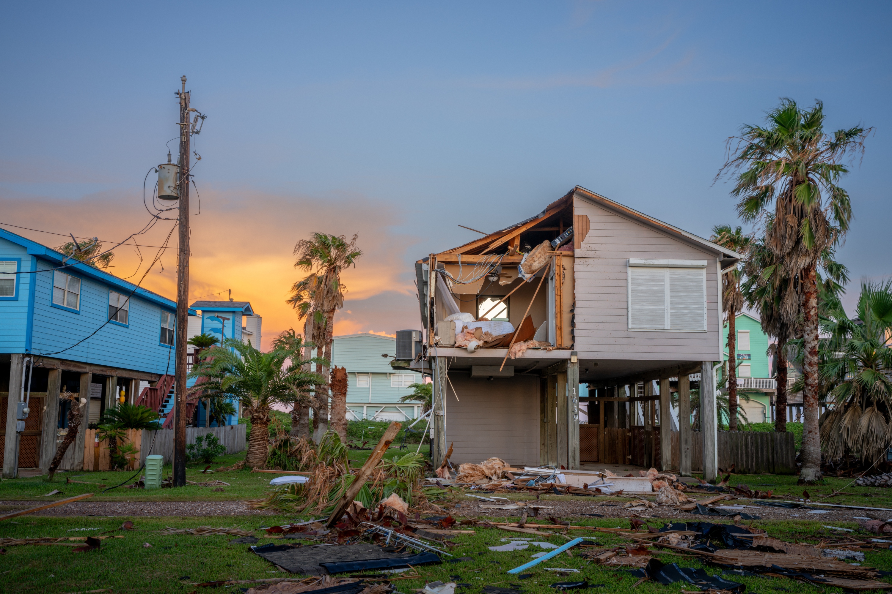
The Mississippi Delta, United States
In North America, the Mississippi Delta has lost approximately 1,900 square miles of land over the last century. Levees designed to protect against flooding have prevented the river from depositing the sediment needed to keep the delta above water. Ohenhen’s analysis shows the region continues to sink by an average of two inches per year, leaving it increasingly vulnerable to the intensified storm surges associated with modern hurricanes.
Official Responses and the Need for Local Action
The revelation that scientific assessments have been "systematically underestimated" has sent ripples through international development and climate adaptation circles. Organizations like the World Bank and the IPCC rely on these models to allocate billions of dollars in climate finance. If the baselines are off by a foot or more, then current seawalls, dikes, and drainage systems are being built to withstand yesterday’s threats, not tomorrow’s.
Matt Palmer of the U.K. Met Office noted that the impacts of climate change will likely be felt much earlier than predicted, necessitating a "rapid reassessment" of coastal defense strategies. Similarly, Franck Ghomsi of the University of Cape Town emphasized that for developing nations with limited resources, this data is a "game changer" that demands more urgent international support.
However, there is a glimmer of hope in the data. Unlike the global rise of sea levels, which requires a worldwide reduction in carbon emissions, land subsidence can be addressed through local policy.
The Tokyo Success Story
Between 1920 and 1960, parts of Tokyo sank by as much as 15 feet due to industrial groundwater extraction. Recognizing the existential threat, the Japanese government implemented strict bans on groundwater pumping and invested in alternative water sources. By the 1970s, the subsidence had almost entirely stopped, and the land has remained stable for decades. This serves as a primary template for cities like Jakarta and Bangkok.
Broader Impact and Future Implications
The combined findings of these studies suggest that the global map will look very different by mid-century. If the current rate of subsidence persists alongside corrected sea-level baselines, an additional area the size of the United Kingdom—home to 132 million people—will fall below the water line.
This is not merely an environmental issue; it is a matter of global security and economic stability. The loss of fertile deltas like the Mekong and the Nile will disrupt global food chains, while the forced migration of tens of millions from sinking megacities could trigger unprecedented humanitarian crises.
The immediate takeaway for policymakers is clear: the era of relying on crude global models is over. To protect coastal populations, governments must invest in localized, real-world measurements that account for both the dynamic movement of the ocean and the shifting ground beneath their feet. As the sea rises to meet a sinking shore, the window for adaptation is closing much faster than we realized.


