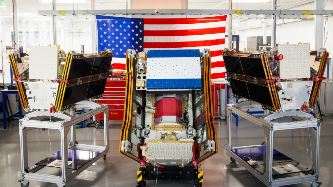
As smoke from hundreds of raging wildfires choked vast swathes of Canada and the United States, cloaking major cities in hazardous haze, a significant leap in environmental monitoring was achieved: the successful launch of the first three operational satellites in the Google-backed FireSat program. These advanced microsatellites, designed to provide unparalleled wildfire detection capabilities, represent a pivotal moment in humanity’s ongoing struggle against increasingly destructive blazes. Following a three-month calibration and testing period, these orbital sentinels are poised to begin actively spotting even nascent fires across the United States, Australia, and Europe before the end of 2026, offering a critical new tool for fire agencies globally.
The launch, executed on July 7, 2026, aboard a SpaceX Falcon 9 rocket from Vandenberg Space Force Base in California, marks the transition to "initial operational capability" for the FireSat constellation. This ambitious project, managed by the nonprofit Earth Fire Alliance, aims to transform wildfire management by providing rapid, precise, and consistent data. Once fully operational, these three satellites will cover every fire-prone region on Earth at least twice daily, significantly improving response times and potentially mitigating the scale of future catastrophes.
The Genesis of FireSat: A New Era in Wildfire Surveillance
The concept behind FireSat emerged from a growing recognition that existing satellite infrastructure, while useful, was not purpose-built for the unique challenges of wildfire detection. Traditional environmental satellites often have longer revisit times or lack the specific spectral bands and resolution needed to penetrate dense smoke or identify small, low-intensity fires. The Earth Fire Alliance, established with a mission to leverage technology for global wildfire resilience, identified this critical gap and spearheaded the development of a dedicated satellite constellation.
The program has garnered substantial financial backing from leading philanthropic and technology giants. Google has committed over $15 million to support the initial deployment, demonstrating a keen interest in applying technological innovation to address pressing climate challenges. This investment underscores Google’s broader initiative to leverage artificial intelligence and cutting-edge research for climate resilience. Complementing Google’s support, the Bezos Earth Fund, founded by Amazon’s Jeff Bezos, pledged a significant $26 million, highlighting a shared vision among tech leaders to invest in solutions for environmental protection. This multi-faceted financial support has been instrumental in transforming the FireSat vision into an orbiting reality.
The satellites themselves are the brainchild of Muon Space, a California-based satellite manufacturer specializing in novel Earth observation platforms. Muon Space’s expertise in designing resilient, high-performance microsatellites has been crucial in developing a system capable of withstanding the rigors of space while delivering highly precise data. Their collaborative effort with the Earth Fire Alliance has resulted in a constellation specifically engineered to overcome the limitations of previous wildfire monitoring systems.
Technological Prowess: Peering Through the Smoke

What sets FireSat apart is its innovative technological core. Each satellite is equipped with advanced multispectral imaging capabilities, a key feature that allows it to "peer through smoke and clouds." Unlike conventional optical sensors that can be blinded by smoke plumes, FireSat’s instruments utilize specific infrared wavelengths that can detect the heat signatures of fires even when obscured. This allows for the identification of blazes that would be invisible to human observers or less sophisticated satellite systems.
Crucially, FireSat boasts an unprecedented ability to detect fires as small as five by five meters—approximately 16 by 16 feet. This level of granular detection is a game-changer. Existing operational satellites, such as those in the NOAA or NASA constellations (e.g., MODIS, VIIRS, GOES), typically have lower spatial resolutions, meaning they can only reliably detect fires once they’ve grown to a larger size, often several acres. By the time these larger fires are spotted, they may have already spread beyond easy containment, requiring far more resources and posing greater threats. The ability to identify fires at their infancy provides a critical window for rapid response, potentially allowing ground crews or aerial assets to suppress them before they escalate into uncontrollable infernos.
The efficacy of this technology was unequivocally proven by a FireSat Protoflight satellite, which launched in March 2025. During its mission, this precursor satellite collected over one million images, demonstrating its capacity to detect low-intensity blazes that existing satellites simply could not see. This successful protoflight mission provided the empirical data and confidence necessary to proceed with the full operational constellation, validating the design and imaging capabilities under real-world conditions.
A Phased Rollout: From Initial Operations to Global Coverage
The July 7, 2026 launch marks a significant milestone, ushering in the "initial operational capability" phase. Over the next three months, the three newly launched satellites will undergo rigorous calibration and testing to ensure their systems are performing optimally and that data transmission is seamless. By the end of the year, this data will begin flowing to a select group of "early adopter" organizations, including fire agencies in California and Colorado in the United States, as well as agencies in Australia and Portugal. These initial partners will integrate FireSat data into their existing incident command systems, providing invaluable feedback for the program’s refinement.
The Earth Fire Alliance has an ambitious roadmap for the constellation’s expansion. As more satellites are launched in subsequent missions, the FireSat program aims to provide the latest imagery anywhere in the world on an hourly basis by 2029. This frequent revisit rate would dramatically improve situational awareness for firefighters and land managers, allowing them to track fire progression and deploy resources with greater precision. The ultimate goal, projected for the early 2030s, is to deploy a full constellation of more than 50 satellites, which would enable imagery updates every 20 minutes. Such near real-time data would represent a paradigm shift in wildfire detection and response, offering a continuous pulse on global fire activity.
Projected Impact: Saving Lives, Land, and Billions
The potential benefits of the FireSat constellation are staggering, extending far beyond mere detection. The Earth Fire Alliance has conducted comprehensive projections, estimating that even an hourly revisit rate could lead to substantial positive outcomes. These include saving more than $1 billion in fire damage costs annually, preventing nearly 22 million tons of carbon emissions from entering the atmosphere, and protecting 3,500 homes and 1.3 million acres of land. These figures underscore the profound economic, environmental, and humanitarian impact that timely wildfire detection can have.

The economic costs of wildfires are immense, encompassing not only direct property damage but also losses in tourism, agricultural productivity, timber resources, and the significant expenses associated with firefighting operations and post-fire recovery. Early detection and rapid suppression can drastically reduce these costs. Environmentally, preventing large-scale fires means preserving critical ecosystems, reducing habitat loss, and avoiding the massive release of greenhouse gases that contribute to climate change, creating a dangerous feedback loop.
Central to maximizing FireSat’s utility is the integration of artificial intelligence. Google Research plays a pivotal role in this aspect, planning to leverage the company’s advanced AI models to process and interpret the vast amounts of data streaming from the satellites. These AI systems will compare operational FireSat data with historical images, enabling them to accurately identify even the smallest fires and to differentiate them from other heat sources. Furthermore, Google’s AI will be used to inform predictive modeling of wildfires, forecasting potential spread patterns based on real-time and historical data, weather conditions, and fuel loads. Google celebrated the launch of the first operational FireSat satellites as "another tangible step forward in putting practical AI to work for climate resilience," highlighting the transformative potential of combining satellite technology with advanced machine learning.
The Escalating Global Wildfire Crisis: A Dire Backdrop
The launch of FireSat occurs against a backdrop of an escalating global wildfire crisis, starkly illustrated by the infernos currently engulfing Canada. In the summer of 2026, hundreds of blazes ripped through Canada’s vast boreal forests, unleashing immense smoke clouds that drifted across the continent. This pervasive smoke has inflicted hazardous air pollution upon more than 100 million people, stretching from Canadian cities deep into the US Midwest, Mid-Atlantic, and Northeast. Air quality alerts became commonplace, with particulate matter levels reaching dangerous highs, prompting public health warnings and impacting daily life for millions. These fires have also forced thousands of people, particularly from vulnerable First Nations communities, to evacuate their homes, disrupting livelihoods and causing immense distress.
The current Canadian wildfire season is not an isolated event but part of a disturbing trend. Canada experienced two of its most destructive wildfire seasons in 2023 and 2025, with the last three fire seasons collectively ranking among the ten worst on record. This pattern is directly linked to climate change, which is driving warmer temperatures, prolonged droughts, and increased fuel aridity across the globe. As Werner Kurz, a retired senior research scientist at Natural Resources Canada, succinctly put it to The Atlantic, "What is unfolding is what climate and forest scientists have been predicting for 30 years. That as the world gets hotter and drier, we are exposing forests to more and more risk, and the old strategies of fire suppression are simply being overwhelmed."
Overwhelmed Defenses: Challenges in Traditional Fire Management
Traditional fire suppression methods, while essential, are proving increasingly inadequate against the sheer scale and intensity of modern wildfires. In remote, mostly uninhabited forest regions, firefighting relies heavily on specialized assets such as fixed-wing air tankers dropping fire retardants and heavy-lift helicopters transporting firefighting crews to remote sites. However, these resources are finite and often stretched thin. In Canada, individual provinces typically bear the primary burden of acquiring or contracting these expensive firefighting aircraft, leading to regional disparities in capacity. In recent years, every available aircraft has frequently been deployed, highlighting a critical resource crunch. Recognizing this, the Canadian federal government leased 10 new aerial firefighting aircraft in May 2026 to provide surge capacity for provinces struggling to contain the escalating blazes.
As of July 17, 2026, the Canadian Wildland Fire Information System reported nearly 900 active wildfires across the country, with over 3,600 fires recorded year-to-date, burning more than 6.6 million acres. Alarmingly, dozens of these are classified as "out of control" and are simply being monitored rather than actively suppressed. This grim reality underscores the difficult decisions fire agencies are forced to make when managing limited resources and weighing the risks to firefighters’ lives. When fires are too large, too remote, or too dangerous to directly attack, strategies shift to containment or monitoring, allowing them to burn until weather conditions change or they reach natural barriers.

The AI Paradox: Innovation vs. Environmental Footprint
While the FireSat program represents a significant technological advancement for climate resilience, it also brings into focus a critical paradox: the environmental cost of the very AI models and data centers driving such innovations. Silicon Valley’s accelerating rush to deploy newer, more powerful AI models comes with a considerable climate footprint. Large AI data centers demand massive amounts of electricity, a demand often met by new natural gas projects in the United States. Projections indicate that the greenhouse gases from this data center boom could collectively emit more than 129 million tons annually, underscoring a growing environmental concern.
Google, a key backer of FireSat and a leader in AI development, has publicly acknowledged the challenges of deploying enough clean energy projects to offset potential emissions from its energy-hungry data centers. The company’s own electricity usage grew by a staggering 37 percent in 2025, largely attributed to its expanding AI infrastructure. This raises important questions about the overall sustainability of rapid AI development. While AI offers powerful tools for climate solutions like wildfire detection, its underlying infrastructure demands careful scrutiny to ensure that the solutions do not inadvertently exacerbate the problem. Tech giants are increasingly investing in renewable energy and efficiency measures, but the pace of AI growth presents a formidable challenge to maintaining carbon neutrality.
Beyond Detection: A Holistic Approach to Resilience
FireSat’s advanced detection capabilities are undeniably a crucial component in the global fight against wildfires, offering unprecedented early warning and situational awareness. However, it is essential to recognize that detection is just one element of a multifaceted strategy necessary to prevent blazes from spiraling out of control. Fire agencies require sufficient resources not only to respond to fires but also to proactively manage ecosystems through methods like prescribed burns. These controlled burns are vital for reducing hazardous fuel loads, promoting forest health, and preventing more severe, uncontrollable fires. Yet, implementing prescribed burns faces numerous challenges, including narrow weather windows, public perception, and regulatory hurdles.
Ultimately, combating the growing wildfire threat demands a holistic approach that integrates technological innovation with robust land management practices, community preparedness, and supportive public policy. This includes investing in more firefighting personnel and equipment, developing climate-resilient infrastructure, fostering international cooperation for resource sharing, and implementing long-term strategies for adapting to a warming planet. FireSat represents a powerful new eye in the sky, offering humanity a clearer, earlier view of impending danger. Its success, however, will be measured not just by its ability to spot fires, but by the collective will to act decisively on the information it provides, coupled with a renewed commitment to comprehensive wildfire management and climate action.