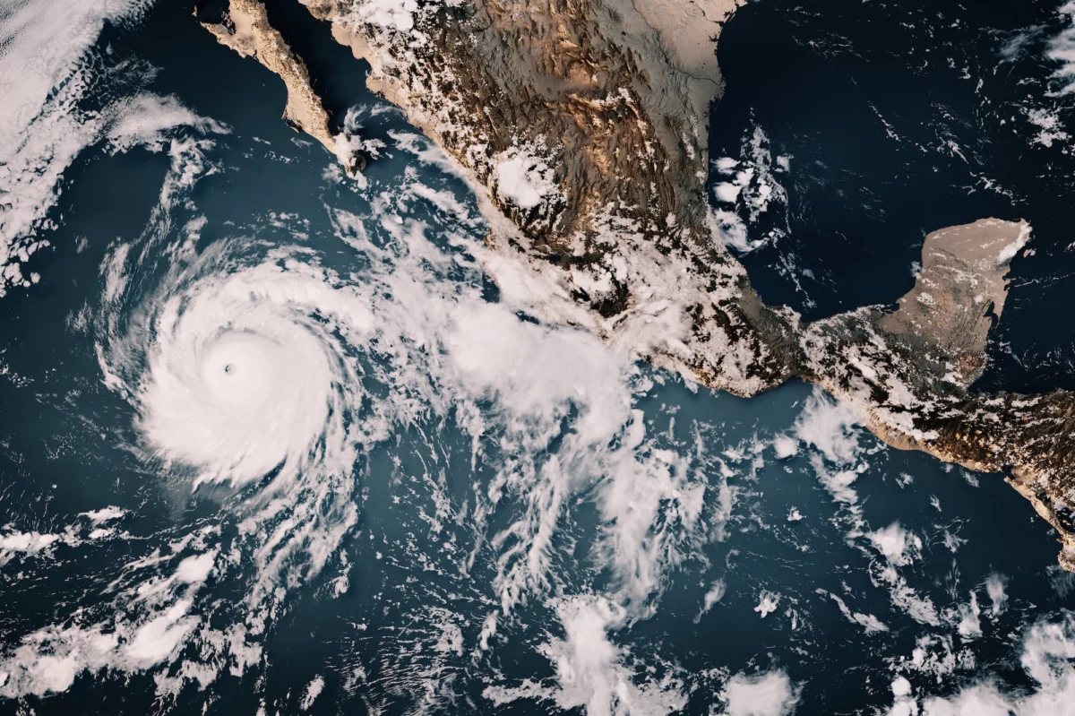
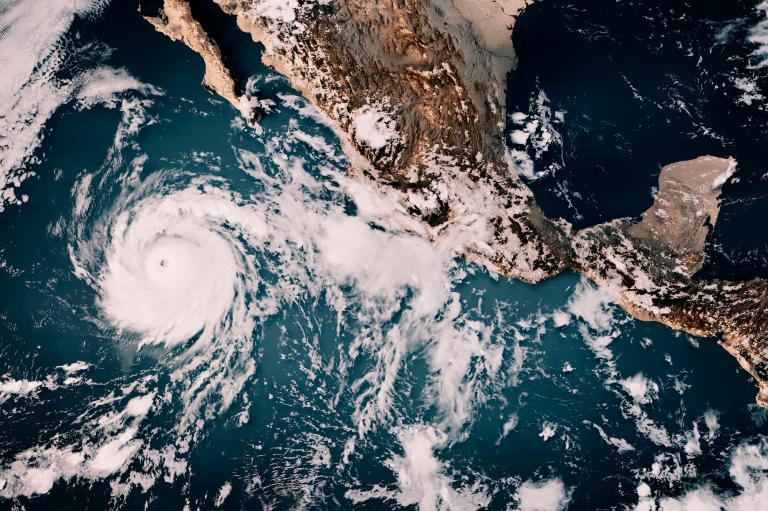
The Pacific Ocean is currently playing host to a climate phenomenon of unprecedented scale, threatening to upend normal weather patterns, stress municipal infrastructure, and fundamentally alter agricultural output across the globe. This meteorological giant—officially recognized as the strongest El Niño on record—is driven by a massive band of anomalously warm water stretching across the equatorial Pacific off the coast of South America. While El Niño cycles typically occur every three to five years, raising surface ocean temperatures for a duration of nine to twelve months, the intensity of the current event has far exceeded historical observations. Climate scientists note that the oceans possess a thermal mass roughly one thousand times greater than that of the atmosphere, meaning that even fractional increases in sea-surface temperatures inject staggering amounts of thermodynamic energy into the global climate system.
As meteorologists and climatologists monitor the trajectory of this exceptionally powerful weather driver, communities worldwide are bracing for a cascade of severe impacts. The phenomenon does not merely warm the atmosphere; it actively restructures jet streams, redirects storm tracks, and creates a volatile mix of severe droughts, torrential deluges, and compounding ecological crises. While the immediate peak of the event is projected to unfold over the coming months, its lingering atmospheric and hydrological consequences are expected to resonate well into late 2027.
The Anatomy and Chronology of a Super El Niño
To understand the scope of the current crisis, it is necessary to examine the mechanics and timeline of the El Niño-Southern Oscillation (ENSO) cycle. The development of this record-breaking phase began quietly in the mid-months of the year, with subsurface ocean temperatures steadily rising along the equatorial Pacific. By late summer, oceanic Kelvin waves—masses of warm water surging eastward across the Pacific basin—began slamming into the West Coast of the Americas, accelerating the surface warming trend.
By September, climate monitoring agencies confirmed that the threshold for a "super" El Niño had been decisively crossed. Art Miller, a climate scientist at the Scripps Institution of Oceanography, emphasized the profound implications of these thermal shifts, pointing out that the ocean’s immense heat content allows minor shifts at the surface to exert a disproportionate influence on global atmospheric circulation. Unlike previous moderate events, this iteration has rewritten charts maintained by the National Oceanic and Atmospheric Administration (NOAA) and international research groups, eclipsing benchmarks set during prior major events in 1997-1998 and 2015-2016.
Researchers are actively investigating the intersection between this natural cycle and long-term anthropogenic climate change. While ENSO is an inherently natural oscillation, empirical evidence suggests that a warming baseline planet may be intensifying the frequency and severity of extreme phases. Consequently, climatologists view the current super El Niño as a chilling preview of default global climate conditions anticipated in the coming decades.
Global Repercussions and Mortality Projections
The repercussions of the 2026-2027 El Niño extend far beyond localized inconveniences, posing direct threats to human health, food security, and economic stability. Scientific assessments coordinated by international impact research groups estimate that the excess thermal energy and associated extreme weather could contribute to approximately 450,000 deaths worldwide due to heat stress, vector-borne diseases, and infrastructure failures associated with natural disasters.
The global precipitation map has been starkly divided. On one hand, severe droughts are strangling critical ecosystems, most notably the Amazon rainforest, where plunging water levels and prolonged dry spells have triggered a surge in destructive wildfires. Conversely, catastrophic rainfall has battered regions such as the Greater Horn of Africa, displacing vulnerable populations and overwhelming rudimentary drainage systems. Furthermore, interactions between El Niño and the stratospheric polar vortex—a band of frigid air encircling the Arctic—have introduced an unpredictable wild card, raising the probability of sudden, erratic cold-air outbreaks across North America and parts of Europe.
Regional Breakdown: United States Impacts
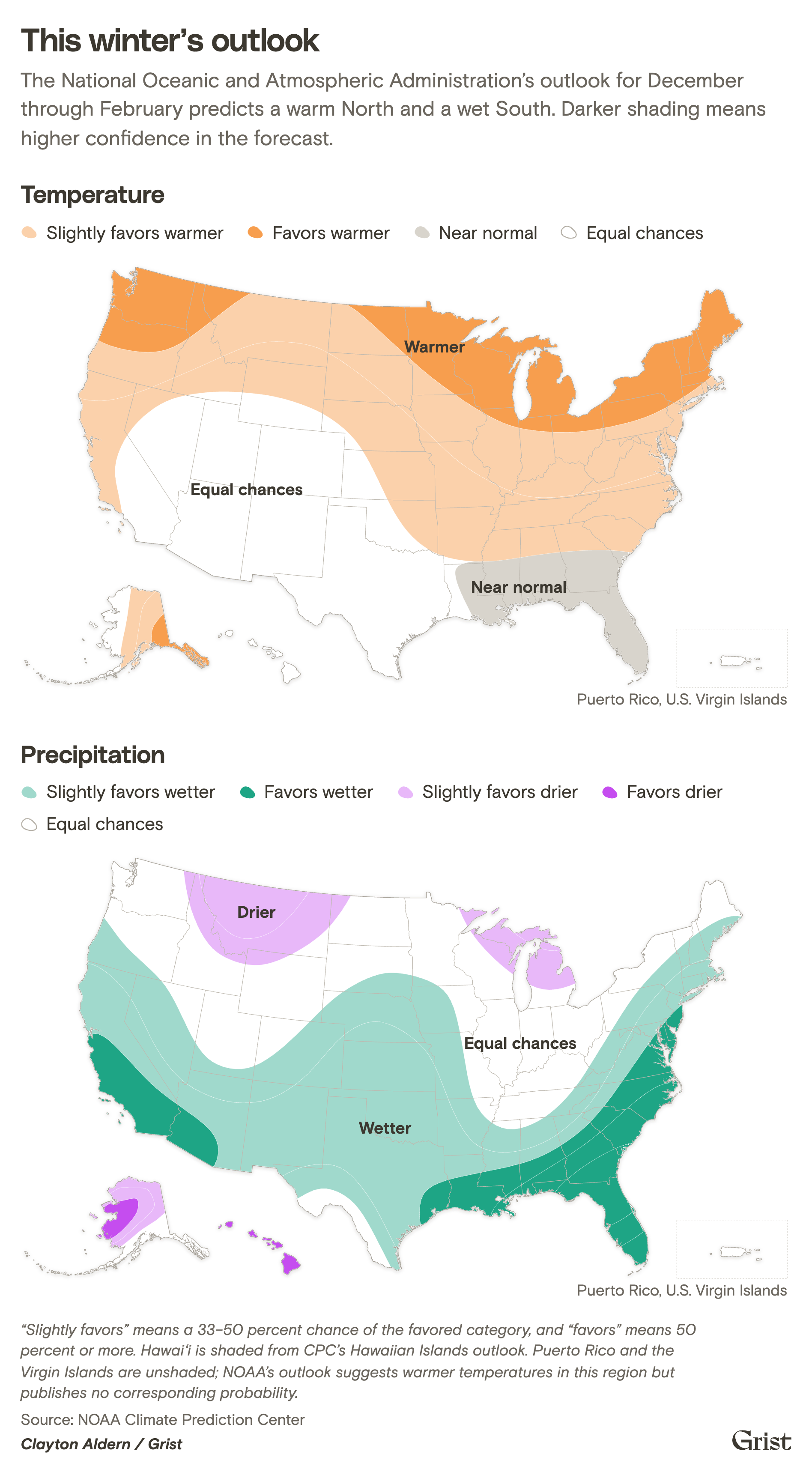
Within the United States, the federal winter outlook for December through February highlights a stark geographical divide: a persistently warm North paired with a unusually wet South. State climatologists and emergency management officials have mobilized to address the highly specific vulnerabilities facing different regions of the country.
The Pacific Northwest and Alaska
In Alaska, where background warming is occurring at rates multiple times faster than the global average, the arrival of a strong El Niño exacerbates pre-existing vulnerabilities. Martin Stuefer, the state climatologist and director of the Alaska Climate Research Center at the University of Alaska Fairbanks, notes that while forecasting specific localized outcomes remains challenging due to the variable behavior of the Aleutian Low, historical precedents point toward warmer winter temperatures and increased winter precipitation falling as rain rather than snow. This reduction in snowpack compounds ongoing crises involving melting sea ice, thawing permafrost, and disrupted marine ecosystems.
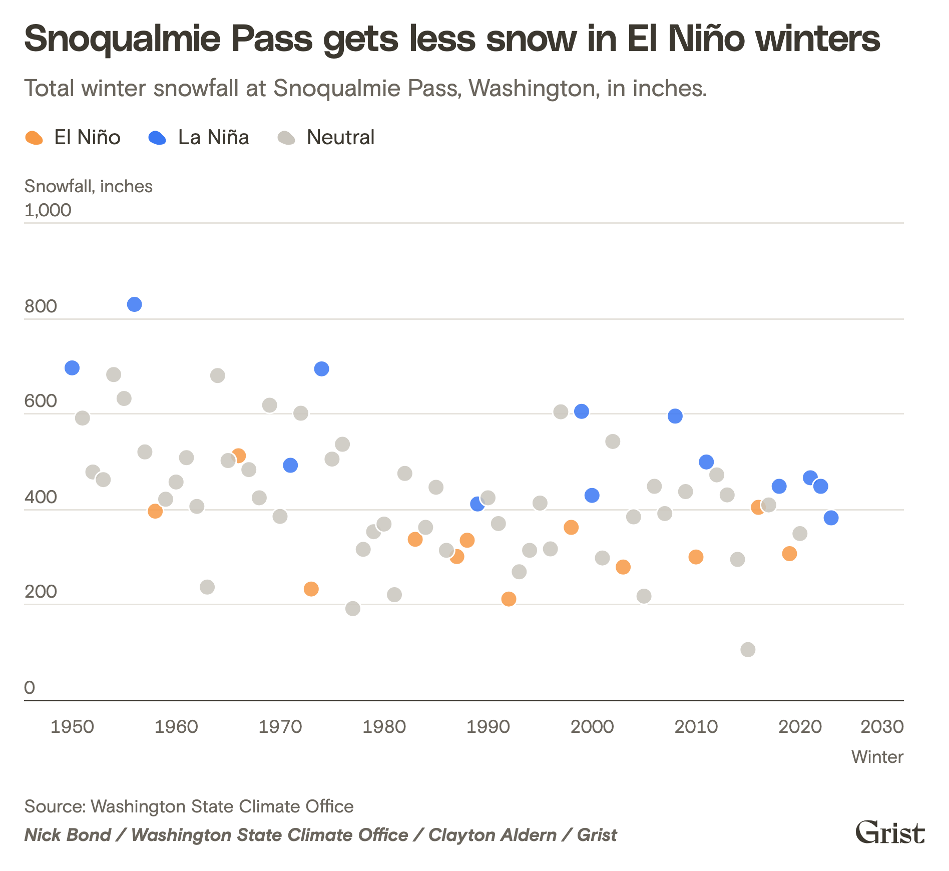
Further south, the Pacific Northwest faces a dual threat of reduced mountain snowpack and elevated coastal flood risks. As storm tracks are deflected southward toward California, the Northwest risks experiencing both warmer temperatures and lower precipitation totals. Because the region relies heavily on snowmelt for summer water supplies, irrigation, and hydropower, a depleted snowpack threatens agricultural and municipal sectors alike. Additionally, shifting ocean and wind patterns are raising high tide levels along the coast, amplifying the danger of tidal flooding when combined with sea-level rise and winter storm surges.
California and the Southwest
California stands at the epicenter of El Niño’s hydrological extremes. Having endured years of historic drought punctuated by sudden deluges, the state is once again preparing for an onslaught of atmospheric rivers. Governor Gavin Newsom proclaimed a state of emergency to accelerate statewide preparedness, focusing heavily on mitigating coastal erosion and catastrophic urban flooding.
The structural challenge for municipal planners is formidable. Traditional civil engineering has long prioritized the rapid channeling of stormwater away from urban centers via concrete culverts and rivers. However, modern initiatives are shifting toward "sponge" infrastructure—such as urban roadside bioswales and groundwater recharge basins—designed to capture stormwater and replenish subterranean aquifers. Despite the immediate relief provided to parched reservoirs, water experts issue a familiar caveat: a single exceptionally wet winter cannot permanently resolve the long-term water deficits plaguing the American West, particularly given the over-allocation of the Colorado River basin.
Meanwhile, Arizona, New Mexico, and parts of the Great Basin are experiencing a mix of beneficial storm activity and destructive flash flooding. While increased precipitation provides a temporary boost to depleted reservoirs like Lake Mead and Lake Powell, the rapid swings between extreme drought and extreme wetness underscore a volatile new normal driven by climate change.
The Midwest and Great Plains
The agricultural heartland of the United States is anticipating a generally milder and drier winter, a pattern traditionally associated with the northward displacement of the polar jet stream. Daria Kluver, a professor of earth and atmospheric sciences at Central Michigan University, highlights that the Midwest experienced its warmest September on record, a trend expected to persist through the winter months. Reduced ice cover on the Great Lakes will likely allow stored summer heat to dissipate into the surrounding atmosphere, influencing regional winter recreation and lake-adjacent ecosystems.
On a positive note, climate models suggest the region may experience a quieter severe weather season in terms of springtime tornadoes, as convective storm tracks are projected to shift southward toward the Gulf Coast states. In the Northern and Southern Great Plains, however, conditions remain a transitional toss-up. States like Nebraska, Kansas, and Texas face a complex matrix of persistent long-term drought paired with the distinct possibility of localized heavy rainfall events, prompting state agencies—such as the Texas Railroad Commission—to issue formal operational warnings to the energy sector regarding potential disruptions outside historical norms.
The Northeast and Southeast
The Northeast is tracking a greater-than-50-percent probability of a milder-than-normal winter, accompanied by above-average precipitation. While private and public forecasters debate total snowfall projections along the densely populated I-95 corridor, hydrologists and urban planners warn that a wintry mix of rain, sleet, and ice presents severe hazards for urban infrastructure and vehicular travel. Nevertheless, a milder winter offers potential relief from high home-heating costs following the persistent cold snaps of previous years.

In the Southeast, El Niño typically establishes a reliable conduit for moisture streaming eastward from the Gulf of Mexico. This dynamic is projected to alleviate or fully erase the severe drought conditions that plagued the region over the preceding year, during which historic dryness triggered widespread agricultural disasters and destructive spring wildfires. However, meteorologists caution that the combination of moist southern air and periodic incursions of Arctic air creates ideal conditions for damaging ice storms, tree damage, and extended power outages. Conversely, a major silver lining for the Southeast is the suppression of Atlantic hurricane formation, providing a welcome reprieve to coastal communities—though localized exceptions remain possible in regions like South Florida and the Bahamas.
Hawai’i and the Pacific Islands
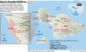
Island communities across the Pacific have already endured a punishing sequence of Kona lows, hurricanes, and typhoons over the past year. Looking ahead, the National Oceanic and Atmospheric Administration warns of an above-normal typhoon season for regions such as Guam and the Commonwealth of the Northern Mariana Islands, alongside a significantly drier winter and spring wet season for Hawai’i.
Ryan Longman, program director at the Pacific Islands Climate Adaptation Science Center, notes that the combination of heavy summer vegetation growth followed by drying conditions sharply elevates wildfire risks. Furthermore, historical data indicates that the most severe drought impacts in the Pacific often manifest in the calendar year immediately following the onset of an El Niño event, pointing toward sustained environmental and agricultural stress well into 2027.
Economic, Agricultural, and Policy Implications
The convergence of record-breaking ocean temperatures and extreme regional weather shifts places an immense burden on global supply chains and agricultural markets. Crop yields in both hemispheres face severe volatility, ranging from flood-drowned fields in California’s Central Valley to drought-stricken grain production across parts of the developing world. Municipalities, utility providers, and emergency management agencies are increasingly forced to transition from reactive disaster response to proactive climate resilience planning.
As the 2026 super El Niño continues to evolve, it serves as a stark reminder of the delicate equilibrium governing Earth’s climate systems. Whether communities are fortifying urban watersheds against torrential downpours, clearing dry brush to mitigate wildfire risks, or revising long-term water management strategies in arid basins, the lessons learned during this historic meteorological event will permanently shape global approaches to infrastructure design, public safety, and climate adaptation for decades to come.