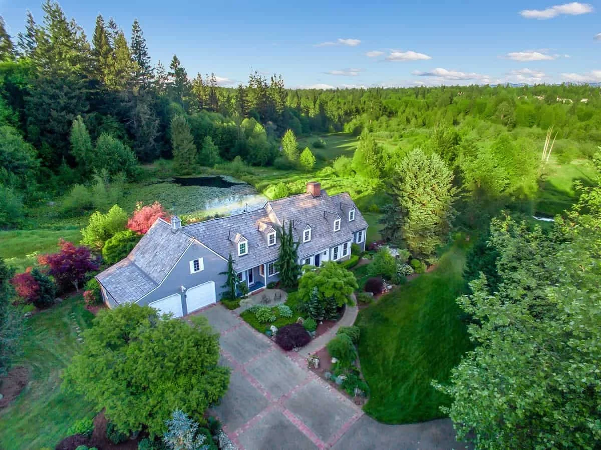
The integration of aerial imagery into modern real estate marketing has fundamentally transformed how properties are showcased, moving the buyer’s perspective from the sidewalk to the skies. As the real estate industry continues to embrace high-definition video passes and top-down photography captured by unmanned aerial vehicles (UAVs), sellers face a new set of preparation demands. While traditional curb appeal focuses on the front door, clean windows, and manicured lawns, aerial photography expands the visual frame to 150 or 200 feet overhead. From this elevated vantage point, structural elements such as the roof and driveway dominate the composition, while minor oversights like stray garden hoses, recycling bins, and seasonal debris become magnified. Consequently, preparing a residential property for a drone shoot requires a meticulous approach to exterior staging, maintenance audits, and environmental coordination.
The evolution of real estate marketing over the past decade highlights a clear shift toward immersive, multi-dimensional media packages. According to multiple industry housing reports, listings featuring comprehensive visual media—including floor plans, virtual tours, and aerial photography—tend to capture buyer attention significantly faster than those relying solely on standard interior snapshots. As more metropolitan housing markets across the United States become increasingly competitive, real estate agents and brokerages increasingly rely on drone assets to differentiate their listings. Whether marketing a single-story ranch home in Houston or a sprawling five-bedroom estate in Atlanta, the fundamental objective of aerial media remains consistent: to eliminate visual clutter, provide a transparent layout of the lot boundaries, and emphasize the functional lifestyle potential of outdoor spaces.
To understand the mechanics of effective aerial preparation, industry experts emphasize the importance of viewing the property through the lens of the camera. Haye Kesteloo, Founder and Editor-in-Chief of DroneXL, notes that perspective changes entirely at higher elevations. From 150 feet up, the roof functions as the primary visual anchor of the frame rather than the entryway. Kesteloo advises homeowners to approach roof maintenance with the same care dedicated to front lawns—clearing gutters, eliminating leaves and pine needles, and addressing moss streaks or abandoned satellite dishes prior to the scheduled flight. Furthermore, practical timing considerations are paramount; simple steps such as clearing vehicles from driveways, rolling away municipal waste bins, closing garage doors, and avoiding lawn irrigation systems immediately before a flight prevent dark pavement blotches and logistical obstructions.
Beyond structural surfaces, the top-down perspective introduces unique challenges regarding ground-level organization. Justin Phillips of American Guerilla Marketing underscores that aerial photography exposes the entire perimeter of a property simultaneously. While small items like stray pool toys, gardening tools, or scattered patio cushions might easily escape notice during a ground-level walkthrough, they become glaring distractions from directly overhead. Sellers are urged to conduct a comprehensive perimeter sweep to inspect driveways, side yards, patios, and pool decks. While staged elements such as an aligned outdoor dining set or a clean grill add valuable context regarding how the space can be utilized, unmanaged items create visual noise that detracts from the property’s intrinsic value.
The logistical coordination of a real estate drone shoot demands a structured timeline mirroring professional home inspections or appraisal appointments. Karl Roskamp of Launchpad Home Group compares the scheduling of aerial media sessions to mandatory home sale evaluations, noting that any physical barrier or delay compromises efficiency. Homeowners must remove vehicles from driveways well in advance, trim overgrown tree branches that obscure vital architectural features or rooflines, and establish a clear, safe launch and landing zone for the pilot. Crucially, arboricultural maintenance must be handled with discretion; aggressive or poorly timed tree trimming leaves fresh cuts, bare patches, and scattered debris that photograph more poorly than the original foliage.
Technical compliance and regulatory safety represent another critical layer in the execution of professional real estate drone media. Commercial drone operations in the United States are strictly regulated by the Federal Aviation Administration (FAA) under Part 107 rules. Jeffrey R. Theisler of Imaging in the Sky emphasizes that property sellers should leave aviation logistics entirely to certified professionals. Licensed operators are equipped to manage airspace authorizations, local flight restrictions, weather evaluations, and liability requirements. Theisler also highlights the critical influence of environmental lighting, noting that flat overcast conditions can diminish a property’s visual appeal, whereas capturing footage during the golden hour shortly before sunset dramatically enhances the warmth and depth of the exterior imagery.
The broader market implications of high-quality aerial photography extend directly to buyer engagement and valuation transparency. In competitive housing markets where prospective buyers often evaluate dozens of digital listings before scheduling an in-person viewing, first impressions are almost exclusively digital. Aerial media provides a distinct advantage by illustrating property size, neighborhood density, proximity to natural amenities such as trails or waterfronts, and the general condition of neighboring lots. However, transparency is equally vital. While staging can significantly improve the aesthetic appeal of a patio or garden, concealing foundational structural defects through digital manipulation or strategic framing is discouraged, as independent home inspectors will ultimately reveal underlying issues during the due diligence phase. Instead, preparation should focus on removing temporary clutter rather than masking permanent conditions.
To ensure optimal results, real estate professionals recommend a systematic pre-shoot checklist executed the evening prior to the appointment. This checklist includes conducting a dual-perspective walkthrough from both the street and the backyard, ensuring all exterior lighting fixtures are functional, confirming that window screens are clean and uniform, and verifying that neighboring properties are free from major visual distractions if visible within the camera’s wide-angle frame. By treating the preparation phase as an essential component of the listing strategy rather than a superficial cleanup task, homeowners can maximize the impact of their marketing investment. Ultimately, when a property is properly cleared, maintained, and staged for overhead viewing, aerial photography fulfills its primary purpose: providing prospective buyers with a clear, honest, and compelling representation of the home and its surrounding environment.