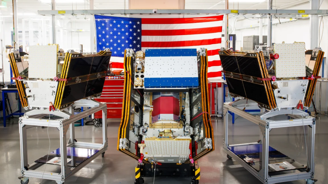
As vast plumes of smoke from hundreds of raging wildfires continue to blanket regions across Canada and the United States, a critical new tool in the global fight against these destructive blazes has reached orbit. The first three operational satellites of the Google-backed FireSat program successfully launched into space, marking a pivotal moment in wildfire detection technology. These microsatellites are poised to begin providing unprecedented wildfire detection capabilities by the end of the year, focusing initially on high-risk areas in the United States, Australia, and Europe. Their primary mission is to spot even the smallest of fires, often missed by existing satellite systems, enabling earlier intervention and potentially mitigating catastrophic damage.
The launch, executed aboard a SpaceX Falcon 9 rocket from Vandenberg Space Force Base in California on July 7, 2026, signifies the transition to "initial operational capability" for the FireSat constellation. This ambitious project is managed by the nonprofit Earth Fire Alliance, a consortium dedicated to leveraging advanced technology for environmental protection. Following a rigorous three-month testing period, these inaugural satellites will commence actively transmitting vital data to fire agencies worldwide. Their coverage promises to encompass every fire-prone region on Earth at least twice per day, dramatically enhancing surveillance capabilities in vulnerable landscapes.
The Genesis and Technological Edge of FireSat
FireSat represents a groundbreaking endeavor as the first satellite constellation specifically engineered and purpose-built for comprehensive wildfire detection. Its design philosophy centers on identifying nascent blazes before they can escalate into uncontrollable infernos. The satellites, meticulously crafted by California-based satellite manufacturer Muon Space, boast sophisticated multispectral imaging technology. This advanced capability allows them to penetrate through dense smoke and cloud cover, a significant limitation for many conventional Earth observation satellites, and detect fires as diminutive as five by five meters—roughly 16 by 16 feet.
The efficacy of this technology was unequivocally demonstrated by a FireSat Protoflight satellite, which launched in March 2025. During its mission, the protoflight unit collected over one million images, proving its capacity to identify low-intensity blazes that remained invisible to existing satellite networks. This successful proof-of-concept underscored the potential of the FireSat system to provide critical early warnings, offering firefighters a crucial head start against rapidly spreading fires.
The development and deployment of FireSat have been significantly bolstered by substantial financial backing from leading technology and philanthropic entities. Google has committed over $15 million to support the initial deployment phases, recognizing the program’s alignment with its broader climate resilience initiatives. In a further testament to its perceived impact, the Bezos Earth Fund has pledged an additional $26 million, highlighting the widespread belief in FireSat’s potential to revolutionize wildfire management on a global scale. This blend of corporate innovation and philanthropic commitment underscores the urgency and importance of addressing the escalating wildfire crisis.

Expanding Coverage and Future Ambitions
The "early adopter" organizations, which will begin integrating FireSat data into their operational strategies this year, include fire agencies in fire-prone regions such as California, Colorado, Australia, and Portugal. These regions are consistently at the forefront of wildfire challenges, experiencing increasing frequency and intensity of fires due to changing climate patterns. The insights provided by FireSat are expected to empower these agencies with actionable intelligence, allowing for more strategic deployment of resources and proactive suppression efforts.
The current deployment is merely the initial phase of a much larger vision. As additional satellites are launched in the coming years, the FireSat program aims to achieve hourly imagery updates anywhere in the world by 2029. This frequent refresh rate would represent an exponential leap in observational capacity, providing near real-time intelligence on fire outbreaks. The ultimate goal is to establish a full constellation of more than 50 satellites by the early 2030s, which would enable imagery updates every 20 minutes. Such an unparalleled level of persistent surveillance would offer fire managers an almost continuous view of fire activity, enabling rapid assessment and response to emerging threats.
Projected Impact: Saving Lives, Land, and Billions
The ability to detect small wildfires before they can grow into uncontrollable conflagrations holds immense promise for mitigating their devastating consequences. The Earth Fire Alliance has conducted extensive projections on the potential benefits of the FireSat constellation. Their analyses suggest that even an hourly revisit rate could lead to staggering savings and environmental protection. Specifically, they project that FireSat could help save more than $1 billion in fire damage costs annually. This figure encompasses not only direct property losses but also indirect economic impacts such as business disruption, agricultural losses, and the immense costs associated with large-scale fire suppression efforts.
Beyond economic benefits, the environmental advantages are equally compelling. The Alliance estimates that FireSat could prevent nearly 22 million tons of carbon emissions each year. Wildfires are a significant contributor to global greenhouse gas emissions, creating a dangerous feedback loop where more fires exacerbate climate change, which in turn fuels more intense fires. By reducing the scale and intensity of blazes, FireSat offers a tangible pathway to curbing these emissions. Furthermore, the program is projected to protect approximately 3,500 homes and safeguard 1.3 million acres of land annually, preserving vital ecosystems, biodiversity, and human communities from destruction.
Google Research is playing a crucial role in maximizing the utility of FireSat data. The company plans to deploy its advanced artificial intelligence (AI) models to analyze the operational FireSat data. By comparing current imagery with vast historical datasets, Google’s AI can accurately identify very small fires, even those that might be subtle or obscured, and filter out false positives. Moreover, these AI models will be instrumental in informing predictive modeling of wildfires, forecasting their likely spread, intensity, and potential impact zones. Google celebrated the launch of the first operational FireSat satellites as "another tangible step forward in putting practical AI to work for climate resilience," highlighting the company’s commitment to leveraging its technological prowess for environmental solutions.

The Intensifying Global Wildfire Crisis and Climate Change
The launch of FireSat occurs against a backdrop of an increasingly severe global wildfire crisis, inextricably linked to the pervasive impacts of climate change. The current wildfire season in Canada, for instance, has generated an unprecedented volume of smoke, affecting vast swathes of both Canadian and US cities. This smoke has inflicted hazardous air pollution upon more than 100 million people, leading to health advisories, school closures, and significant disruption to daily life. In Canada, thousands of people, particularly within vulnerable First Nations communities, have been forced to evacuate their homes, underscoring the profound social and cultural impacts of these escalating blazes.
The wildfires raging through Canada’s boreal forests are burning with a ferocity and scale rarely seen before, a direct consequence of the hotter, drier conditions driven by anthropogenic greenhouse gas emissions. The years 2023 and 2025 witnessed two of Canada’s most destructive wildfire seasons on record, and the past three fire seasons collectively rank among the top ten worst in recorded history. These statistics paint a stark picture of a rapidly deteriorating situation, where traditional fire management strategies are increasingly overwhelmed.
Werner Kurz, a retired senior research scientist at Natural Resources Canada, succinctly articulated the grim reality: "What is unfolding is what climate and forest scientists have been predicting for 30 years. That as the world gets hotter and drier, we are exposing forests to more and more risk, and the old strategies of fire suppression are simply being overwhelmed." This sentiment is echoed by countless climate scientists globally, who point to rising global temperatures, prolonged droughts, and increased fuel loads as primary drivers behind the intensification of wildfires across various continents.
Traditional fire suppression efforts, particularly in vast, mostly uninhabited forest regions, rely heavily on specialized resources such as fixed-wing air tankers and heavy-lift helicopters. These aircraft are essential for dropping fire retardants over active blazes and for rapidly transporting firefighting crews to remote sites. However, the sheer scale and concurrent nature of recent wildfire events have severely strained these resources. Individual Canadian provinces typically bear the financial burden of acquiring or contracting these expensive firefighting aircraft, leading to capacity constraints. In recent years, every available aircraft has often been deployed, yet still proved insufficient. In response to this escalating crisis, the Canadian government took proactive measures this year, leasing 10 new aerial firefighting aircraft to serve as surge assets for provinces in critical need.
As of July 17, the Canadian Wildland Fire Information System reported nearly 900 active wildfires across the country. To date, Canada has experienced more than 3,600 wildfires, which have collectively scorched over 6.6 million acres—an area larger than the country of Belgium. Among these, dozens of wildland fires are classified as "out of control," meaning they are being monitored rather than actively suppressed. This grim reality highlights the agonizing decisions fire agencies are forced to make when confronted with limited resources and the paramount need to prioritize the safety of firefighters, often leading to a strategy of containment rather than direct attack in remote or high-risk areas.
The Paradox of AI: Innovation and Environmental Footprint

While Silicon Valley’s rapid deployment of advanced AI models like FireSat offers a glimmer of hope for climate resilience, this technological surge also comes with a considerable environmental cost, paradoxically contributing to the very climate change that fuels the worsening wildfire problem. The infrastructure supporting modern AI, particularly large AI data centers, demands massive amounts of electricity. This burgeoning energy requirement is often being met by the development of new natural gas projects in the United States and elsewhere. According to recent analyses, the greenhouse gases emitted by this data center boom could collectively exceed 129 million tons per year, a figure comparable to the emissions of entire nations.
Google, a leading proponent of AI development and a key backer of FireSat, has itself acknowledged the formidable challenges of deploying sufficient clean energy projects to offset the potential emissions from its increasingly energy-hungry data centers. The company’s own electricity usage, driven largely by its AI buildout, reportedly grew by a staggering 37 percent in 2025 alone. This rapid increase in energy demand underscores a critical tension: while AI offers powerful tools for environmental monitoring and climate modeling, its underlying infrastructure currently presents a significant environmental footprint that needs urgent attention.
Ultimately, Google’s financial and technical support for AI-powered wildfire detection through initiatives like FireSat could prove incredibly helpful in providing early warnings and improving response times. However, wildfire detection is but one component of a multifaceted approach necessary to prevent blazes from spiraling out of control. Effective wildfire management also requires adequate resources for proactive ecosystem management, including prescribed burns to reduce fuel loads, and sufficient capacity to rapidly extinguish unwanted fires. The job of fire agencies worldwide has become exponentially more challenging due to the relentless pressures of global warming, underscoring the need for a holistic strategy that combines technological innovation with robust land management practices and, crucially, aggressive global action on climate change mitigation.
The FireSat constellation represents a significant leap forward in our ability to detect and respond to wildfires with unprecedented speed and precision. Its advanced capabilities offer a powerful new weapon in the arsenal against these increasingly destructive natural disasters. Yet, as the world embraces such technological solutions, it must also confront the broader implications of a warming planet and the environmental costs associated with the very innovations designed to address it. FireSat’s promise lies not just in its ability to peer through smoke, but also in its potential to catalyze a more comprehensive and sustainable approach to managing wildfires in a climate-altered world.