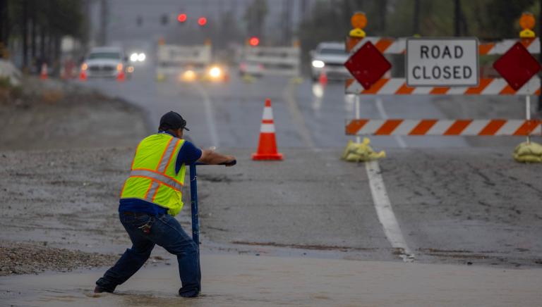
The American Southwest has found itself grappling with a paradox of biblical proportions: receiving too much of a desperately needed good thing. Over the course of a single weekend, a ferocious, moisture-laden storm system inundated desert communities across Arizona, New Mexico, Utah, and Colorado, triggering catastrophic flash floods and claiming at least four lives. While precipitation is the lifeblood of the region’s fragile desert climate, entire states received two to three months’ worth of rain in a matter of days—a deluge far exceeding the capacity of modern human infrastructure. In Clovis, New Mexico, an astounding 28.84 inches of rain has fallen since September 20, eclipsing the city’s historical average of just 3.3 inches and rewriting local meteorological history.
This unprecedented meteorological event is not an isolated anomaly. Climatologists point directly to a powerful El Niño cycle—currently developing into one of the strongest on record—as the primary engine driving these atmospheric rivers into the arid American West. While the Pacific Ocean anomaly introduces only a fraction of a degree in surface warming, that minuscule shift injects a tremendous amount of thermal energy into the atmosphere, completely scrambling historical weather patterns across the globe. As the region picks up the pieces, federal and state agencies are warning that this weekend’s disaster may only be the opening act of a volatile and dangerous winter.
A Relentless Chronology of Extreme Autumn Storms
The recent flash floods did not occur in a vacuum; they were the culmination of an unusually wet, volatile autumn that began building momentum in late September. The timeline of atmospheric distress started taking shape as early as September 20, when persistent low-pressure systems began drawing unprecedented plumes of moisture from a superheated Pacific Ocean directly into the American Southwest.
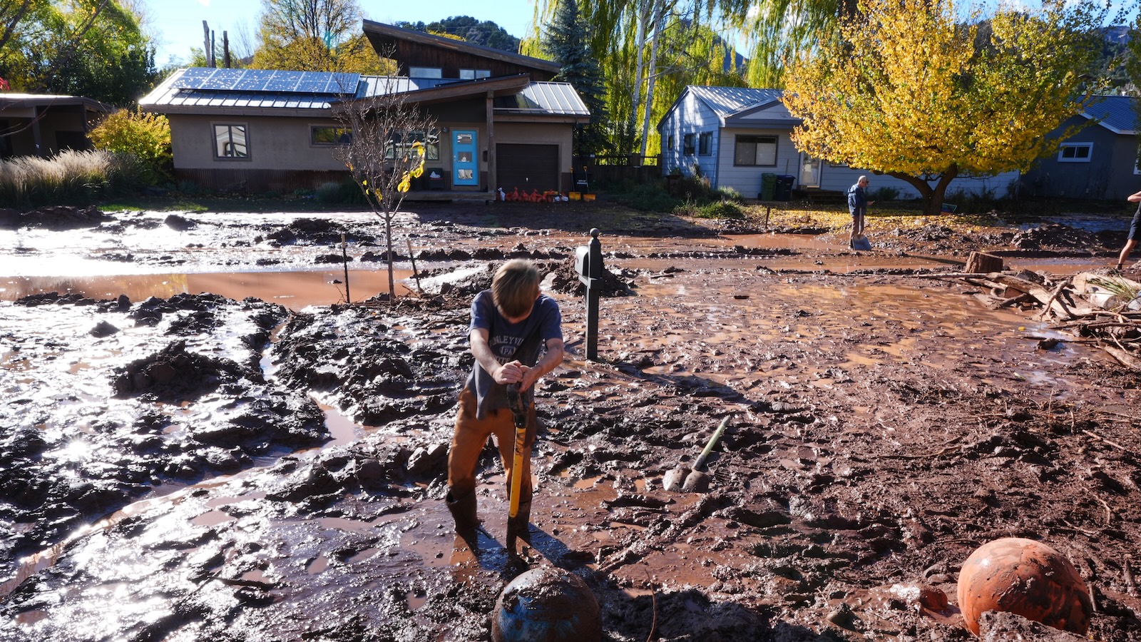
By late October, a separate, highly potent weather system slammed into the higher elevations of Colorado. Pelting the region with up to 8 inches of rain in a mere four-day span, the storm shattered state rainfall records and triggered widespread destruction, washing out mountain passes, stranding motorists, and cutting off remote towns. This relentless barrage of atmospheric moisture saturated regional soils and swelled river basins weeks before the most recent weekend disaster.
When the most recent storm system stalled over Arizona, Utah, and New Mexico, it encountered a landscape completely unprepared to absorb additional water. Because previous storms had already driven soil moisture saturation to historic highs, virtually every subsequent drop of rain transformed instantly into surface runoff. Rivers that were already running dangerously high breached their banks, sweeping away infrastructure and turning quiet desert arroyos into raging torrents. Climatologists emphasize that this compounding effect—where one extreme event primes the landscape for catastrophic failure during the next—is becoming a hallmark of modern western hydrology.
The Science of El Niño and Ocean Heat Anomalies
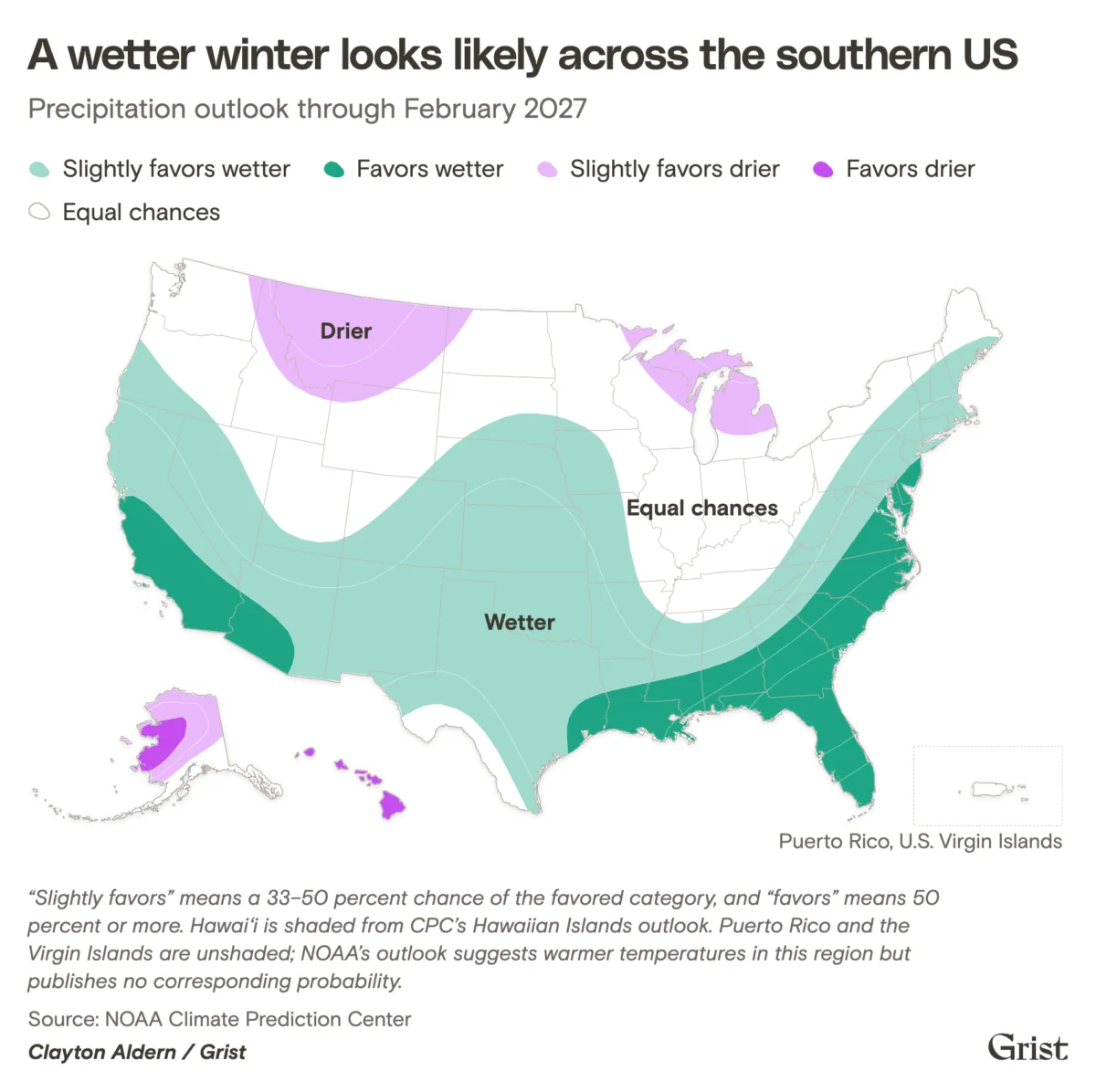
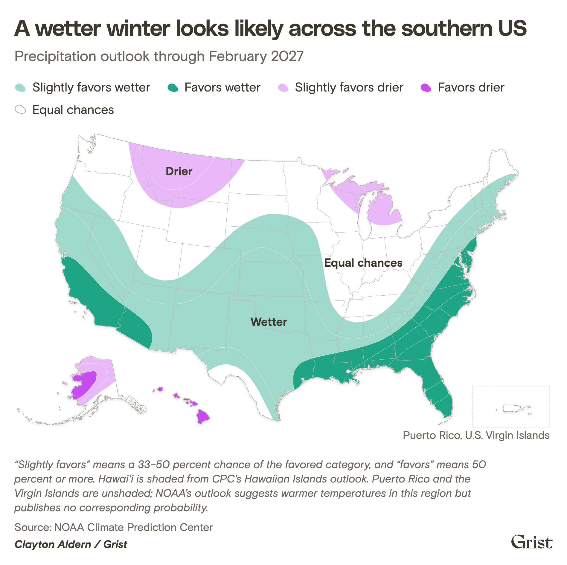
At the heart of this extreme weather volatility is a confluence of oceanic and atmospheric phenomena. Russ Schumacher, the state climatologist and director of the Colorado Climate Center at Colorado State University, notes that the El Niño connection is unmistakable. El Niño, characterized by a vast band of anomalously warm water in the central and eastern equatorial Pacific Ocean, alters high-altitude jet streams and primes the southern tier of the United States for a significantly wetter winter.
Michael A. Crimmins, a climatologist at the University of Arizona, emphasizes the statistical improbability of these events occurring outside the influence of a major El Niño cycle. While severe isolated storms can occur during neutral years, aligning all the necessary meteorological ingredients—boundless atmospheric moisture, favorable jet stream positioning, and persistent blocking patterns—requires a global driver of this magnitude.
Paradoxically, while this same El Niño pattern has supercharged moisture delivery to the American Southwest, it has had the opposite effect in the Atlantic basin. High-altitude wind shear generated by the Pacific warming has effectively suppressed Atlantic hurricane formation. The 2026 Atlantic hurricane season shattered records for the latest first-named hurricane in a season by nearly a month, producing only a single tropical cyclone by a point in the year when six are normally expected.
Conversely, the eastern Pacific has buzzed with activity, spawning 10 hurricanes this season alone. This dynamic underscores a broader, more ominous reality: the world’s oceans have absorbed more than 90 percent of the excess heat trapped by anthropogenic greenhouse gas emissions. This massive reservoir of oceanic heat acts as an invisible engine, supercharging storms and driving extreme atmospheric moisture anomalies across North America.
Topographic Vulnerability and the Legacy of Flash Floods
The physical geography of the Southwest makes it uniquely susceptible to these intense precipitation events. Mountainous terrain, steep canyons, and hard-packed desert soils create a natural funneling system that turns heavy rainfall into lethal flash floods with terrifying speed.
"If you hike around the Southwest, you’re going to see out-of-place boulders all over the place," Crimmins noted, pointing to the ancient geological footprint of water in the desert. "Water put it there. Maybe it was 5,000 years ago or something like that, but water moves. We can have really epic flash flooding."
When sudden walls of water tear through narrow canyons or urbanized desert corridors, traditional drainage systems are overwhelmed almost instantaneously. Unlike prolonged, gentle stratiform rains that gradually soak into aquifers, torrential cloudbursts rush off impermeable rock faces and concrete infrastructure, leaving communities little time to react or evacuate.
Drought Relief Versus the Reality of Long-Term Water Scarcity
For a region that has spent decades locked in a punishing megadrought, the influx of winter precipitation carries a complex duality. On one hand, NOAA’s seasonal outlooks offer a glimmer of hope, predicting that the wetter winter favored by El Niño could significantly improve or entirely end drought conditions across much of the American South, the Southern Plains, and parts of the Southwest.
However, water management experts caution that a single wet winter—even one as aggressive as this—cannot reverse decades of systemic decline in the region’s major watersheds. The Colorado River system, the lifeblood of the Southwest supporting over 40 million people, has seen its two largest storage vessels, Lake Powell and Lake Mead, pushed perilously close to dead pool levels in recent years. While the recent rains and anticipated winter precipitation will provide temporary relief, Russ Schumacher points out the immense deficit facing the basin.
"It’s a long way to go to get even back to where we were a year ago," Schumacher said, "let alone when it was in good condition decades ago." Furthermore, climate change continues to exacerbate these dry spells by driving up surface temperatures, which in turn accelerates evaporation rates from exposed reservoirs. Compounding the crisis is relentless population growth across Southwestern metropolitan centers, driving an ever-increasing demand for a shrinking pool of freshwater.
The Wildcard of Mountain Snowpack
As water managers look ahead to the remainder of the winter, all eyes are fixed on the mountain snowpack. Unlike warm rainwater, which runs off immediately and overburdens municipal flood controls, snow acts as a natural, high-altitude reservoir. Winter snowpacks store precipitation securely in the mountains, releasing the water gradually as temperatures warm during the spring thaw, thereby feeding rivers in a controlled manner throughout the dry summer months.
Following a historically low snowpack earlier this year, the mountainous regions of Colorado, Utah, and New Mexico are in urgent need of heavy snowfall. Climatologists note that it remains too early in the season to predict whether the developing El Niño will deliver the necessary alpine accumulation. A heavy snowpack could provide both immediate soil hydration and sustained summer runoff, whereas a warm, rain-dominant winter would likely exacerbate flooding risks while failing to secure long-term water storage.
Adapting Infrastructure for a Volatile Climate
Faced with the reality of intensifying weather extremes, municipal leaders and water agencies across the Southwest are fundamentally rethinking how they interact with stormwater. Rather than viewing heavy precipitation purely as a destructive hazard or rushing it out to sea through concrete culverts, forward-thinking cities are reimagining urban design.
In Tucson, Arizona, and other desert municipalities, investments in green infrastructure are transforming the urban landscape. By constructing engineered bioswales, retention basins, and unpaved native plant habitats, cities are deliberately slowing the velocity of stormwater runoff. These decentralized systems allow floodwaters to infiltrate the soil, replenishing local shallow aquifers while hydrating native desert flora.
"There’s really cool and clever ways of thinking about stormwater as a resource rather than a nuisance," Crimmins said.
As climate change continues to amplify hydrological extremes—swinging the pendulum violently between historic droughts and catastrophic floods—the ability of Southwestern communities to adapt their infrastructure will determine their long-term viability. The recent autumn deluge serves as a stark reminder that while the desert can temporarily quench its thirst, managing the sheer force of water in a warming world requires unprecedented ingenuity, resilience, and respect for nature’s immense power.